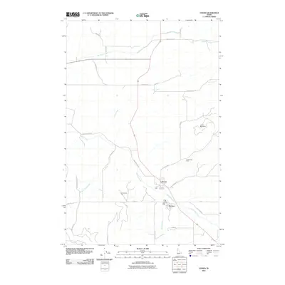
2010 Map of Tensed
USGS Topo · Published 2010About this map
Tensed and De Smet anchor this rural landscape in Benewah County, where the topography transitions from the agricultural flats of King Valley to the more prominent elevations of ukwle' Mountain and Iron Mountain. The drainage pattern is defined by several converging watercourses, including Hangman Creek, Lolo Creek, and Moctileme Creek, which carve through the terrain. Cultural and natural landmarks such as Chaats'alalqs Grove and Ni lukhwalqw Gap reflect the unique heritage of the region. The road network, including the historically named Mail Route Rd and Old Tensed Rd, suggests a long-standing system of rural transport and mail delivery connecting these small communities at the start of the 21st century.
Find a feature on this map
29 named features on this map. Tap any name to fly to it.
Don’t see what you’re looking for? This feature index may not catch every label — zoom into the map to look around manually.
Map Details
Editions of this 2010 Tensed Map
This is the sole edition of this map. No revisions or reprints were ever made.
Other maps of this area

1903 · Oakesdale
USGS Topo · 1:125,000

1905 · Oakesdale
USGS Topo · 1:125,000

1954 · Fairfield
USGS Topo · 1:62,500

1955 · Spokane
USGS Topo · 1:250,000

1957 · Plummer
USGS Topo · 1:62,500

1957 · Tensed
USGS Topo · 1:62,500

1958 · Spokane
USGS Topo · 1:250,000

1964 · Tekoa
USGS Topo · 1:24,000
1964 · Farmington
USGS Topo · 1:24,000

1975 · Plummer SE
USGS Topo · 1:24,000