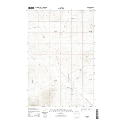
2013 Map of Tensed
USGS Topo · Published 2013About this map
Tensed and the nearby community of De Smet anchor this rural landscape in the southwestern corner of Benewah Co, where the panhandle terrain transitions between the Coeur d'Alene Reservation highlands and fertile agricultural valleys. The mapping preserves indigenous place names alongside settler history, featuring distinctive landmarks like Chaats'ala'qs Grove and the Ni'lukhwalqw Gap. Water defines the geography, with Hangman Cr, Mission Cr, and Moctileme Cr carving paths through the rolling hills.
Find a feature on this map
39 named features on this map. Tap any name to fly to it.
Don’t see what you’re looking for? This feature index may not catch every label — zoom into the map to look around manually.
Map Details
Editions of this 2013 Tensed Map
This is the sole edition of this map. No revisions or reprints were ever made.
Other maps of this area

1903 · Oakesdale
USGS Topo · 1:125,000

1905 · Oakesdale
USGS Topo · 1:125,000

1954 · Fairfield
USGS Topo · 1:62,500

1955 · Spokane
USGS Topo · 1:250,000

1957 · Plummer
USGS Topo · 1:62,500

1957 · Tensed
USGS Topo · 1:62,500

1958 · Spokane
USGS Topo · 1:250,000

1964 · Tekoa
USGS Topo · 1:24,000
1964 · Farmington
USGS Topo · 1:24,000

1975 · Plummer SE
USGS Topo · 1:24,000