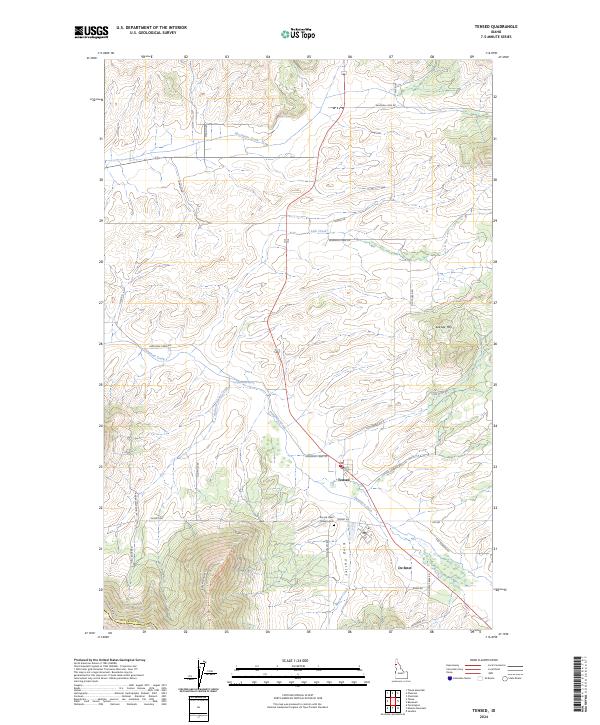
2024 Map of Tensed
USGS Topo · Published 2024About this map
Tensed and De Smet anchor this rural landscape in Benewah County, where the hills transition into the drainage systems of the Palouse region. The area is defined by a network of seasonal and perennial waterways, most notably Hangman Creek, which flows westward through the center of the quadrangle. Local heritage is centered near the Sacred Heart Mission Cem south of Tensed, situated along Desmet Rd near the headwaters of Mission Creek. The terrain rises to notable peaks such as Lukw'le' Mtn in the east, while the valley floors are traced by Moctileme Creek and Lolo Creek. A dense grid of rural routes, including Old Tensed Rd and Mail Route Rd, provides access to the surrounding agricultural and timber lands, reflecting the long-standing importance of these corridors for local transport and settlement connectivity.
Find a feature on this map
40 named features on this map. Tap any name to fly to it.
Don’t see what you’re looking for? This feature index may not catch every label — zoom into the map to look around manually.
Map Details
Editions of this 2024 Tensed Map
This is the sole edition of this map. No revisions or reprints were ever made.
Other maps of this area

1903 · Oakesdale
USGS Topo · 1:125,000

1905 · Oakesdale
USGS Topo · 1:125,000

1954 · Fairfield
USGS Topo · 1:62,500

1955 · Spokane
USGS Topo · 1:250,000

1957 · Plummer
USGS Topo · 1:62,500

1957 · Tensed
USGS Topo · 1:62,500

1958 · Spokane
USGS Topo · 1:250,000

1964 · Tekoa
USGS Topo · 1:24,000
1964 · Farmington
USGS Topo · 1:24,000

1975 · Plummer SE
USGS Topo · 1:24,000