
1942 Map of Tent Hills
USGS Topo · Published 1960About this map
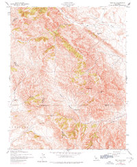
Avenal Ridge dominates the center of this map, marking a high divide between several California counties at the time of these 1942 aerial surveys. The landscape is defined by its ranching heritage, with private holdings such as Iron Spring Ranch, Fahey Ranch, and Acebedo Ranch scattered through the canyons. Topographical features like Three Peaks and Johnson Peak provide significant landmarks overlooking Sunflower Valley to the northeast. This terrain is notably intersectional, showing the convergence of four county lines: Monterey, Kings, San Luis Obispo, and Kern. Movement through this upland area was dictated by natural gaps, most notably Cottonwood Pass, which connects the drainage of Cottonwood Creek with the lower elevations to the west. The map captures a moment of sparse high-country settlement where seasonal water sources like Little Avenal Creek and Sunflower Creek were critical for local operations at places like Hay Flat.
Find a feature on this map
25 named features on this map. Tap any name to fly to it.
Don’t see what you’re looking for? This feature index may not catch every label — zoom into the map to look around manually.
Map Details
Editions of this 1942 Tent Hills Map
2 editions found
Other maps of this area

1914 · Cholame
USGS Topo · 1:125,000

1915 · Cholame
USGS Topo · 1:125,000

1917 · Cholame
USGS Topo · 1:125,000

1930 · Kettleman Plain
USGS Topo · 1:31,680

1933 · Kettleman Plain
USGS Topo · 1:31,680

1934 · The Dark Hole
USGS Topo · 1:31,680

1934 · Reef Ridge
USGS Topo · 1:31,680
1937 · Reef Ridge
USGS Topo · 1:31,680
1937 · The Dark Hole
USGS Topo · 1:31,680
1943 · Cholame
USGS Topo · 1:31,680