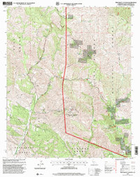
1995 Map of Tepusquet Canyon
USGS Topo · Published 2000About this map
The Suey Grant, Tepusquet Grant, and Sisquoc Grant define the land divisions of this California interior, where steep canyons and high ridges separate historic ranchlands and public wilderness. The landscape is dominated by the Los Padres National Forest, with significant topographical features including Tepusquet Peak and the winding course of Tepusquet Canyon. For the local historian and genealogist, the map records specific points of human history such as the Ontiveros Cem and the isolated Ruiz Grave. These markers, along with the Goodchild Ranch, reflect the area's legacy of private land holdings amidst the broader national forest. The map also identifies industrial and recreational sites, from scattered Oil Wells and a Quarry to remote locations like Bear Campsite and Alejandro Campsite, accessed via rugged routes like Tepusquet Road and Colson Canyon Road.
Find a feature on this map
40 named features on this map. Tap any name to fly to it.
Don’t see what you’re looking for? This feature index may not catch every label — zoom into the map to look around manually.
Map Details
Editions of this 1995 Tepusquet Canyon Map
This is the sole edition of this map. No revisions or reprints were ever made.
Other maps of this area

1905 · Lompoc
USGS Topo · 1:125,000

1922 · Nipomo
USGS Topo · 1:62,500

1937 · Branch Mtn
USGS Topo · 1:48,000

1942 · Lompoc
USGS Topo · 1:125,000

1942 · Santa Maria
USGS Topo · 1:62,500

1942 · Branch Mountain
USGS Topo · 1:62,500

1942 · Tepusquet Peak
USGS Topo · 1:62,500

1943 · Tepusquet Peak
USGS Topo · 1:62,500

1943 · Lompoc
USGS Topo · 1:125,000

1947 · Careaga Canyon
USGS Topo · 1:24,000