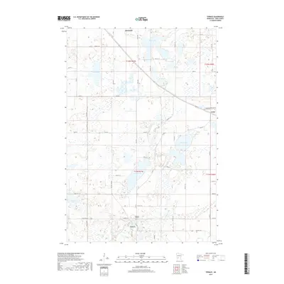
2019 Map of Terrace
USGS Topo · Published 2019About this map
Terrace and the meandering E Br Chippewa River anchor this landscape in Pope County. The geography is defined by a dense network of glacial water bodies, from the sprawling Marlu Lake and Swenoda Lake to the smaller Marlu Millpond, which hints at the hydraulic history of the region. The settlement of Sedan sits in the eastern reaches, while the rural interior is dotted with local heritage sites like Chippewa Falls Cem and the Immaculate Conception Cem. Navigating the area involves a grid of township roads and county routes, including Co Rd 23 and State Hwy 104, which connect these small agricultural communities. The terrain is marked by significant wetlands and seasonal ponds, illustrating the complex drainage patterns that feed into the Anderson Lake basin and beyond.
Find a feature on this map
49 named features on this map. Tap any name to fly to it.
Don’t see what you’re looking for? This feature index may not catch every label — zoom into the map to look around manually.
Map Details
Editions of this 2019 Terrace Map
This is the sole edition of this map. No revisions or reprints were ever made.
Other maps of this area

1953 · Saint Cloud
USGS Topo · 1:250,000

1957 · Saint Cloud
USGS Topo · 1:250,000

1958 · Saint Cloud
USGS Topo · 1:250,000

1965 · Westport
USGS Topo · 1:24,000

1965 · Sedan
USGS Topo · 1:24,000

1967 · Lake Johanna
USGS Topo · 1:24,000

1968 · Glenwood
USGS Topo · 1:24,000

1968 · Terrace
USGS Topo · 1:24,000
1968 · Villard
USGS Topo · 1:24,000

1968 · Lake Simon
USGS Topo · 1:24,000