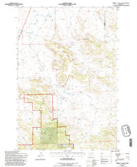
1993 Map of Terrell Creek
USGS Topo · Published 1996About this map
Custer National Forest encompasses the southwestern portion of this 1993 study, where the Ekalaka Hills rise above a landscape defined by an intricate network of drainages and springs. The map documents rural land use in southeast Montana during the early 1990s, recording specific family holdings such as the J. LaBree Ranch and the D. Schwede Ranch. Distinctive geological and terrain features like Chimney Rock and Red Hill provide important landmarks for local navigation and history.
Find a feature on this map
23 named features on this map. Tap any name to fly to it.
Don’t see what you’re looking for? This feature index may not catch every label — zoom into the map to look around manually.
Map Details
Editions of this 1993 Terrell Creek Map
This is the sole edition of this map. No revisions or reprints were ever made.
Other maps of this area

1953 · Miles City
USGS Topo · 1:250,000

1954 · Ekalaka
USGS Topo · 1:250,000

1956 · Ekalaka
USGS Topo · 1:250,000

1957 · Miles City
USGS Topo · 1:250,000

1958 · Miles City
USGS Topo · 1:250,000

1958 · Ekalaka
USGS Topo · 1:250,000

1965 · Ekalaka
USGS Topo · 1:250,000

1979 · Ekalaka
USGS Topo · 1:24,000

1980 · Camp Needmore
USGS Topo · 1:24,000

1980 · Dutchmans Hill
USGS Topo · 1:24,000