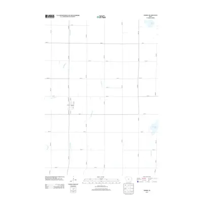
2013 Map of Terril
USGS Topo · Published 2013About this map
Terril is the primary settlement on this Dickinson County landscape, centered at the intersection of W Main St and S State St. The surrounding terrain is defined by a grid of rural avenues and streets that partition the agricultural plains. Significant water features including Twelvemile Lake and Cheever Lake anchor the northeastern and southeastern corners of the quadrangle, while Big Muddy Cr and Pickerel Run provide natural drainage across the fields. The presence of Ditch Number 61 suggests a highly managed hydrological system designed to support the local farming economy. This survey captures the town's layout just south of the intersection at N Schooley St, providing a clear record of the local street grid and the waterways that have shaped the development of this northern Iowa community.
Find a feature on this map
30 named features on this map. Tap any name to fly to it.
Don’t see what you’re looking for? This feature index may not catch every label — zoom into the map to look around manually.
Map Details
Editions of this 2013 Terril Map
This is the sole edition of this map. No revisions or reprints were ever made.
Other maps of this area

1954 · Fairmont
USGS Topo · 1:250,000

1958 · Fairmont
USGS Topo · 1:250,000

1966 · Dickens
USGS Topo · 1:24,000

1970 · Spirit Lake SE
USGS Topo · 1:24,000

1970 · Spirit Lake
USGS Topo · 1:24,000

1972 · Graettinger West
USGS Topo · 1:24,000

1972 · Terril
USGS Topo · 1:24,000

1972 · Wallingford
USGS Topo · 1:24,000

1972 · Estherville
USGS Topo · 1:24,000
1972 · Ruthven
USGS Topo · 1:24,000