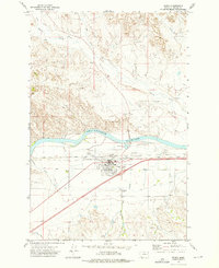
1972 Map of Terry
USGS Topo · Published 1976About this map
The Yellowstone River cuts a wide path through the Montana landscape, anchoring the development of Terry as a key rail and transit point in Prairie County. The town is defined by a dense intersection of transportation infrastructure, where the Chicago Milwaukee St Paul and Pacific and Burlington Northern railroads parallel the river. This proximity to the water is further utilized by the Main Terry Canal and an Aqueduct, illustrating the vital role of irrigation in this semi-arid region.
Find a feature on this map
24 named features on this map. Tap any name to fly to it.
Don’t see what you’re looking for? This feature index may not catch every label — zoom into the map to look around manually.
Map Details
Editions of this 1972 Terry Map
This is the sole edition of this map. No revisions or reprints were ever made.
Other maps of this area

1953 · Miles City
USGS Topo · 1:250,000

1957 · Miles City
USGS Topo · 1:250,000

1958 · Miles City
USGS Topo · 1:250,000

1969 · Zero NE
USGS Topo · 1:24,000

1969 · Zero
USGS Topo · 1:24,000

1969 · Flat Top Butte
USGS Topo · 1:24,000

1972 · Hendrickson Coulee
USGS Topo · 1:24,000

1972 · Calypso
USGS Topo · 1:24,000

1972 · Papps Reservoir
USGS Topo · 1:24,000

1972 · Diamond G Creek
USGS Topo · 1:24,000