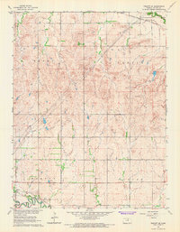
1965 Map of Tescott SE
USGS Topo · Published 1966About this map
The Saline River winds through the southwestern corner of this landscape, where the settlement of Tescott serves as a local hub for transport and commerce. During the mid-1960s, the area's connectivity is defined by two major rail lines: the Union Pacific running parallel to the river and the Atchison Topeka and Santa Fe traversing the northern reaches. The terrain is organized into distinct townships including Henry, Center, Morton, and Culver, reflecting the agrarian structure of rural Ottawa County.
Find a feature on this map
19 named features on this map. Tap any name to fly to it.
Don’t see what you’re looking for? This feature index may not catch every label — zoom into the map to look around manually.
Map Details
Editions of this 1965 Tescott SE Map
This is the sole edition of this map. No revisions or reprints were ever made.
Other maps of this area

1892 · Salina
USGS Topo · 1:125,000

1892 · Minneapolis
USGS Topo · 1:125,000

1942 · Salina
USGS Topo · 1:125,000

1955 · Trenton
USGS Topo · 1:24,000

1955 · Culver
USGS Topo · 1:24,000

1955 · Manhattan
USGS Topo · 1:250,000

1955 · Hutchinson
USGS Topo · 1:250,000

1956 · Manhattan
USGS Topo · 1:250,000

1957 · Manhattan
USGS Topo · 1:250,000

1959 · Hutchinson
USGS Topo · 1:250,000