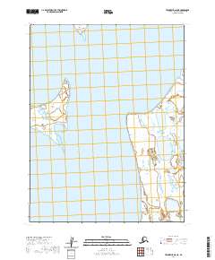
2020 Map of Teshekpuk D-5 NE
USGS Topo · Published 2020About this map
Admiralty Bay and Dease Inlet dominate this coastal reach of the North Slope, where the land and water dissolve into a complex pattern of thaw lakes and low-lying points. The landscape is defined by its maritime features, notably Wright Point, which extends into the inlet, and several small landforms including Tiny Island and the Kikiktak Islands. This 2020 study highlights the intricate shoreline of Oarlock Island, reflecting the dynamic nature of the Arctic coastal environment. Without permanent settlements or roads, the map serves as a primary record of the physical geography and hydrography within the boundaries of t19n r14w and surrounding townships, providing a baseline for understanding the shifting coastal morphology of this remote Alaskan borough.
Find a feature on this map
12 named features on this map. Tap any name to fly to it.
Don’t see what you’re looking for? This feature index may not catch every label — zoom into the map to look around manually.
Map Details
Editions of this 2020 Teshekpuk D-5 NE Map
This is the sole edition of this map. No revisions or reprints were ever made.
Other maps of this area

1945 · Barrow
USGS Topo · 1:250,000

1949 · Barrow
USGS Topo · 1:250,000

1951 · Teshekpuk
USGS Topo · 1:250,000

1955 · Barrow A-2
USGS Topo · 1:63,360

1955 · Barrow
USGS Topo · 1:250,000

1955 · Teshekpuk
USGS Topo · 1:250,000

1955 · Barrow A-3
USGS Topo · 1:63,360
1955 · Teshekpuk D-5
USGS Topo · 1:63,360

1955 · Teshekpuk D-4
USGS Topo · 1:63,360

1964 · Teshekpuk
USGS Topo · 1:250,000