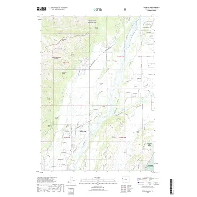
2017 Map of Teton Village
USGS Topo · Published 2017About this map
Teton Village sits at the base of the Teton Range, marking a point where the steep topography of Rendezvous Mtn and Apres Vous Peak transitions into the wide valley of Jackson Hole. The landscape is defined by the convergence of major watercourses, where the Snake River meets the Gros Ventre River amidst a complex network of braids and tributaries like Fish Creek.
Find a feature on this map
109 named features on this map. Tap any name to fly to it.
Don’t see what you’re looking for? This feature index may not catch every label — zoom into the map to look around manually.
Map Details
Editions of this 2017 Teton Village Map
This is the sole edition of this map. No revisions or reprints were ever made.
Other maps of this area

1899 · Grand Teton
USGS Topo · 1:125,000

1901 · Grand Teton
USGS Topo · 1:125,000

1931 · Jackson
USGS Topo · 1:125,000

1935 · Jackson
USGS Topo · 1:125,000

1955 · Driggs
USGS Topo · 1:250,000

1958 · Driggs
USGS Topo · 1:250,000

1962 · Driggs
USGS Topo · 1:250,000

1963 · Jackson
USGS Topo · 1:24,000

1963 · Teton Pass
USGS Topo · 1:24,000
1965 · Cache Creek
USGS Topo · 1:24,000