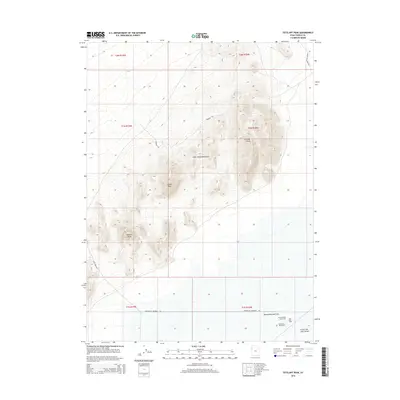
2014 Map of Tetzlaff Peak
USGS Topo · Published 2014About this map
Silver Island Mountains dominate this landscape within the Great Salt Lake Desert, rising sharply above the surrounding salt crust. This 2014 survey captures the distinct intersection of high-altitude peaks and the perfectly level expanses used for world-class racing. Notable summits including Tetzlaff Peak, Rishel Peak, and Volcano Peak provide the backdrop for the famous Bonneville Salt Flats to the south. The southern portion of the sheet is dedicated to speed, detailing the layout of the International Racetrack, the Hot Rod Track, and the Bonneville Racetrack. Access to this remote environment is shown via several desert tracks, including Prospect Rd and Bonneville Speedway Rd, which connect the mountain passes to the expansive racing grounds below.
Find a feature on this map
19 named features on this map. Tap any name to fly to it.
Don’t see what you’re looking for? This feature index may not catch every label — zoom into the map to look around manually.
Map Details
Editions of this 2014 Tetzlaff Peak Map
This is the sole edition of this map. No revisions or reprints were ever made.
Other maps of this area

1953 · Tooele
USGS Topo · 1:250,000

1955 · Tooele
USGS Topo · 1:250,000

1955 · Elko
USGS Topo · 1:250,000

1958 · Elko
USGS Topo · 1:250,000

1962 · Elko
USGS Topo · 1:250,000

1965 · Elko
USGS Topo · 1:250,000

1971 · Silver Island Pass
USGS Topo · 1:24,000
1971 · Miners Canyon
USGS Topo · 1:24,000

1971 · Leppy Peak
USGS Topo · 1:24,000

1971 · Graham Peak
USGS Topo · 1:24,000