
1971 Map of Tetzlaff Peak
USGS Topo · Published 1977About this map
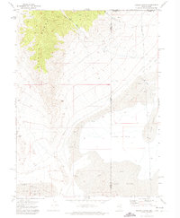
Tetzlaff Peak and the Silver Island Mountains dominate this 1970s orthophotomap, showing the stark transition from high desert peaks to the white expanse of the Bonneville Salt Flats. The survey area includes the legendary International Bonneville Hot Rod Racetrack, where the straightaways of the Racetrack Track meet the Alkali or Mud Flat. The map reveals a landscape defined by extreme geography and specialized land use, from the primitive Jeep Trail routes through Leppy Pass to the industrial presence of an Aqueduct and scattered Prospect sites.
Find a feature on this map
21 named features on this map. Tap any name to fly to it.
Don’t see what you’re looking for? This feature index may not catch every label — zoom into the map to look around manually.
Map Details
Editions of this 1971 Tetzlaff Peak Map
This is the sole edition of this map. No revisions or reprints were ever made.
Other maps of this area

1953 · Tooele
USGS Topo · 1:250,000

1955 · Tooele
USGS Topo · 1:250,000

1955 · Elko
USGS Topo · 1:250,000

1958 · Elko
USGS Topo · 1:250,000

1962 · Elko
USGS Topo · 1:250,000

1965 · Elko
USGS Topo · 1:250,000

1971 · Silver Island Pass
USGS Topo · 1:24,000
1971 · Miners Canyon
USGS Topo · 1:24,000

1971 · Leppy Peak
USGS Topo · 1:24,000

1971 · Graham Peak
USGS Topo · 1:24,000