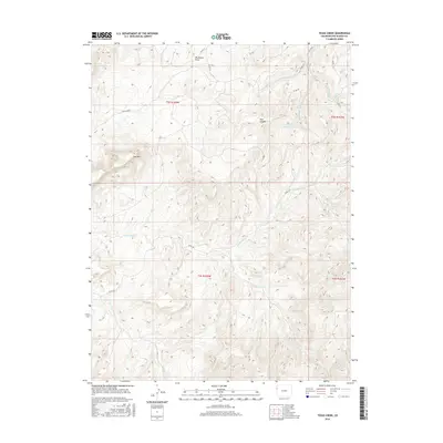
2016 Map of Texas Creek
USGS Topo · Published 2016About this map
Park Mtn stands as a prominent landmark in this high-desert drainage system of Rio Blanco County, where the landscape is defined by an intricate network of seasonal watercourses and deep canyons. The central terrain is carved by the namesake Texas Creek, which is fed by the N Fork Texas Cr and S Fork Texas Cr, illustrating a classic dendritic drainage pattern typical of the Colorado Plateau. This area, largely defined by public land survey townships including t2s r103w and t3s r103w, remains dominated by natural features rather than dense settlement.
Find a feature on this map
22 named features on this map. Tap any name to fly to it.
Don’t see what you’re looking for? This feature index may not catch every label — zoom into the map to look around manually.
Map Details
Editions of this 2016 Texas Creek Map
This is the sole edition of this map. No revisions or reprints were ever made.
Other maps of this area

1885 · East Tavaputs
USGS Topo · 1:250,000

1956 · Grand Junction
USGS Topo · 1:250,000

1959 · Grand Junction
USGS Topo · 1:250,000

1960 · Grand Junction
USGS Topo · 1:250,000

1962 · Grand Junction
USGS Topo · 1:250,000

1964 · Grand Junction
USGS Topo · 1:250,000

1964 · Texas Creek
USGS Topo · 1:24,000

1964 · East Evacuation Creek
USGS Topo · 1:24,000
1964 · Water Canyon
USGS Topo · 1:24,000
1964 · Texas Mountain
USGS Topo · 1:24,000