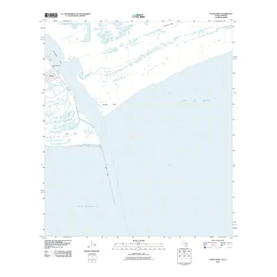
2010 Map of Texas Point
USGS Topo · Published 2010About this map
Sabine and the Texas Menhaden Strip mark a narrow coastal interface where the industrial and maritime activity of Jefferson County meets the Gulf of Mexico. This coastal survey highlights the intricate hydrology of the marshland south of Port Arthur, where the Anchorage Basin provides deep-water access adjacent to the sprawling wetlands of Mud Lake. The landscape is defined by the sharp convergence of Texas Point and Louisiana Point, where the West Jetty extends into the gulf to manage the shifting sediment of the ship channel. Inland, the map reveals a network of waterways including Lighthouse Bayou and Texas Bayou, while Hackberry Ridge provides a rare point of elevation amidst the low-lying coastal prairie. The presence of the menhaden processing area reflects the region's historical ties to the commercial fishing industry and the logistical demands of Gulf Coast shipping.
Find a feature on this map
13 named features on this map. Tap any name to fly to it.
Don’t see what you’re looking for? This feature index may not catch every label — zoom into the map to look around manually.
Map Details
Editions of this 2010 Texas Point Map
This is the sole edition of this map. No revisions or reprints were ever made.
Other maps of this area

1932 · Sabine Pass NE
USGS Topo · 1:31,680

1934 · Johnsons Bayou
USGS Topo · 1:24,000

1935 · Johnsons Bayou
USGS Topo · 1:31,680

1943 · West of Johnson Bayou
USGS Topo · 1:24,000

1943 · Port Arthur South
USGS Topo · 1:24,000

1944 · Sabine Pass
USGS Topo · 1:31,680

1944 · Texas Point
USGS Topo · 1:31,680
1946 · Sabine Pass NE
USGS Topo · 1:31,680
1946 · Port Arthur SE
USGS Topo · 1:31,680

1954 · Port Arthur
USGS Topo · 1:250,000