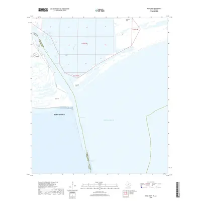
2019 Map of Texas Point
USGS Topo · Published 2019About this map
Sabine Pass serves as the critical maritime artery at the border of Texas and Louisiana, where the waters of the Gulf of Mexico meet the coastal marshlands. This maritime landscape is defined by the heavy engineering of the Jetty Channel and Outer Bar Channel, infrastructure essential for reaching Port Arthur. On the Texas side, the small settlement of Sabine sits near Mud Lake, with streets like 1st Ave and Welch St providing local access. Across the state line in Cameron Parish, the terrain is dominated by Hackberry Ridge and the reach of Lighthouse Bayou. The contrast between the natural curves of Texas Bayou and the straight lines of the deep-water channels highlights the area's role as a primary gateway for Gulf shipping and petrochemical transit.
Find a feature on this map
36 named features on this map. Tap any name to fly to it.
Don’t see what you’re looking for? This feature index may not catch every label — zoom into the map to look around manually.
Map Details
Editions of this 2019 Texas Point Map
This is the sole edition of this map. No revisions or reprints were ever made.
Other maps of this area

1932 · Sabine Pass NE
USGS Topo · 1:31,680

1934 · Johnsons Bayou
USGS Topo · 1:24,000

1935 · Johnsons Bayou
USGS Topo · 1:31,680

1943 · West of Johnson Bayou
USGS Topo · 1:24,000

1943 · Port Arthur South
USGS Topo · 1:24,000

1944 · Sabine Pass
USGS Topo · 1:31,680

1944 · Texas Point
USGS Topo · 1:31,680
1946 · Sabine Pass NE
USGS Topo · 1:31,680
1946 · Port Arthur SE
USGS Topo · 1:31,680

1954 · Port Arthur
USGS Topo · 1:250,000