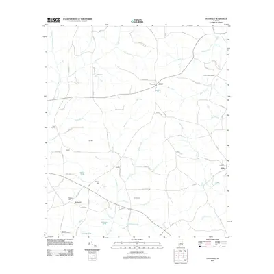
2011 Map of Texasville
USGS Topo · Published 2011About this map
Texasville serves as the focal point of this Barbour County landscape, situated at a junction where local roads meet amid a network of creeks and small family landmarks. This 2011 survey illustrates a region defined by its rural heritage, with small settlements like Edwin and Tew connected by a web of county highways such as Co HWY 43 and Co HWY 70. The topography is marked by several named rises, including Joe Hill, Shipes Hill, and Walker Hill, which overlook the headwaters of the West Fork Choctawhatchee River. Numerous cemeteries, such as Adams Chapel Cemetery and Magnolia Memorial Cemetery, are scattered throughout the quadrangle, indicating long-established family ties to the land. Water features such as Spencers Pond and Lingo Pond dot the terrain, while irrigation and drainage are managed via the Jordan Ditch in the southeast corner.
Find a feature on this map
80 named features on this map. Tap any name to fly to it.
Don’t see what you’re looking for? This feature index may not catch every label — zoom into the map to look around manually.
Map Details
Editions of this 2011 Texasville Map
This is the sole edition of this map. No revisions or reprints were ever made.
Other maps of this area

1953 · Dothan
USGS Topo · 1:250,000

1954 · Dothan
USGS Topo · 1:250,000

1955 · Dothan
USGS Topo · 1:250,000

1967 · Clayton South
USGS Topo · 1:24,000

1968 · Baker Hill
USGS Topo · 1:24,000

1968 · Louisville
USGS Topo · 1:24,000

1969 · Abbeville West
USGS Topo · 1:24,000
1969 · Clio
USGS Topo · 1:24,000
1969 · Texasville
USGS Topo · 1:24,000
1969 · Skipperville
USGS Topo · 1:24,000