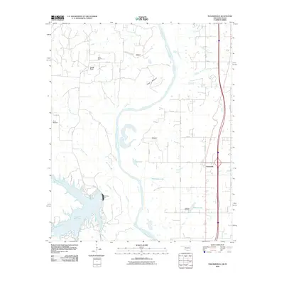
2010 Map of Thackerville
USGS Topo · Published 2010About this map
The Red River snakes through the center of this landscape, forming the natural border between Love County and Texas. On the Oklahoma side, the settlement of Thackerville serves as a primary hub near the interstate corridor, while smaller localities like Bomar sit further north. The terrain is defined by its riparian complexity, featuring numerous water bodies such as Burk Lake, Whittington Lake, and Gladney Lake, which was created by the Gladney Lake Dam. These wetlands and floodplains, including the interestingly named Frog Bottom, indicate a legacy of agricultural and riverine activity.
Find a feature on this map
50 named features on this map. Tap any name to fly to it.
Don’t see what you’re looking for? This feature index may not catch every label — zoom into the map to look around manually.
Map Details
Editions of this 2010 Thackerville Map
This is the sole edition of this map. No revisions or reprints were ever made.
Other maps of this area

1902 · Gainesville
USGS Topo · 1:125,000

1943 · Gainesville
USGS Topo · 1:125,000

1954 · Sherman
USGS Topo · 1:250,000

1958 · Sherman
USGS Topo · 1:250,000

1960 · Callisburg
USGS Topo · 1:24,000

1960 · Gainesville North
USGS Topo · 1:24,000

1961 · Muenster East
USGS Topo · 1:24,000
1967 · Marietta East
USGS Topo · 1:24,000
1968 · Thackerville
USGS Topo · 1:24,000
1968 · Burneyville
USGS Topo · 1:24,000