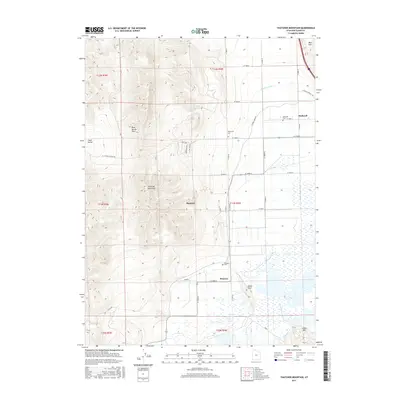
2017 Map of Thatcher Mountain
USGS Topo · Published 2017About this map
Thatcher Mountain and the Blue Spring Hills anchor the western reaches of this Box Elder County terrain, giving way to an organized grid of agricultural development and water management to the east. The communities of Bothwell, Thatcher, and Penrose are situated along this transition, connected by a network of rural roads such as W 12000 N and W 8000 N. The importance of irrigation in this arid landscape is evident through the prominent Highline Canal and West Canal systems that weave through the valley floor. Genealogists will find several burial sites including Bothwell Cem, Valleyview Cem, and Penrose Cem, providing a clear record of local settlement patterns. To the south, the map reaches toward Peterson Pond and Little Mtn, illustrating the varied topography from peak to basin.
Find a feature on this map
37 named features on this map. Tap any name to fly to it.
Don’t see what you’re looking for? This feature index may not catch every label — zoom into the map to look around manually.
Map Details
Editions of this 2017 Thatcher Mountain Map
This is the sole edition of this map. No revisions or reprints were ever made.
Other maps of this area

1954 · Public Shooting Grounds
USGS Topo · 1:24,000

1954 · Brigham City
USGS Topo · 1:250,000

1955 · Bear River City
USGS Topo · 1:24,000

1958 · Brigham City
USGS Topo · 1:250,000

1961 · Thatcher Mountain
USGS Topo · 1:62,500

1961 · Tremonton
USGS Topo · 1:24,000

1962 · Brigham City
USGS Topo · 1:250,000
1964 · Riverside
USGS Topo · 1:24,000

1966 · Thatcher Mountain SW
USGS Topo · 1:24,000

1968 · Howell
USGS Topo · 1:24,000