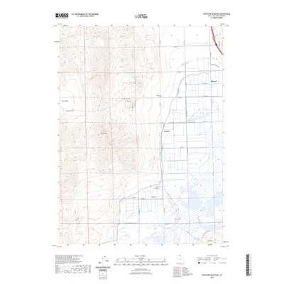
2023 Map of Thatcher Mountain
USGS Topo · Published 2023About this map
Blue Spring Hills and the West Hills frame a landscape defined by an intricate network of irrigation and agricultural settlement in Box Elder County. The communities of Bothwell, Thatcher, and Penrose are oriented along a grid of section-line roads, such as W 12000 N and N 10000 W, which navigate the transition from elevated terrain into the basin. The vital role of water management in this arid region is visible through the Highline Canal and the West Canal, which wrap around the foothills to support local farms. Local history is anchored by the Valleyview Cem and Penrose Cem, while the western portion of the map is dominated by the heights of Thatcher Mtn and the expanse of Faust Valley. To the south, the terrain descends toward the marshy margins of Peterson Pond near Jesses Knoll.
Find a feature on this map
39 named features on this map. Tap any name to fly to it.
Don’t see what you’re looking for? This feature index may not catch every label — zoom into the map to look around manually.
Map Details
Editions of this 2023 Thatcher Mountain Map
This is the sole edition of this map. No revisions or reprints were ever made.
Other maps of this area

1954 · Public Shooting Grounds
USGS Topo · 1:24,000

1954 · Brigham City
USGS Topo · 1:250,000

1955 · Bear River City
USGS Topo · 1:24,000

1958 · Brigham City
USGS Topo · 1:250,000

1961 · Thatcher Mountain
USGS Topo · 1:62,500

1961 · Tremonton
USGS Topo · 1:24,000

1962 · Brigham City
USGS Topo · 1:250,000
1964 · Riverside
USGS Topo · 1:24,000

1966 · Thatcher Mountain SW
USGS Topo · 1:24,000

1968 · Howell
USGS Topo · 1:24,000