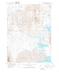
1961 Map of Thatcher Mountain
USGS Topo · Published 1979About this map
Thatcher Mountain and the Promontory Mountains overlook a landscape shaped by both intensive irrigation and conservation efforts in the early 1960s. The agricultural character of Blue Creek Valley is evident in the network of canals and city boundaries surrounding Bothwell, while industrial development is marked by a Chemical Plant situated north of Lampo Junction. Near the center of the sheet, the Union Pacific line serves Thatcher and the Thatcher Siding, providing a vital link for the local economy.
Find a feature on this map
38 named features on this map. Tap any name to fly to it.
Don’t see what you’re looking for? This feature index may not catch every label — zoom into the map to look around manually.
Map Details
Editions of this 1961 Thatcher Mountain Map
2 editions found
Other maps of this area

1954 · Whistler Canal
USGS Topo · 1:24,000

1954 · Public Shooting Grounds
USGS Topo · 1:24,000

1954 · Brigham City
USGS Topo · 1:250,000

1955 · Mouth of Bear River
USGS Topo · 1:24,000

1955 · Bear River City
USGS Topo · 1:24,000

1958 · Brigham City
USGS Topo · 1:250,000

1961 · Thatcher Mountain
USGS Topo · 1:62,500

1961 · Tremonton
USGS Topo · 1:24,000

1962 · Brigham City
USGS Topo · 1:250,000
1964 · Riverside
USGS Topo · 1:24,000