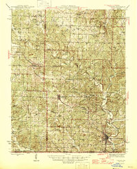
1946 Map of Thayer
USGS Topo · Published 1946About this map
Koshkonong and Thayer anchor this mid-1940s survey of the Ozark highlands along the Missouri-Arkansas border. The landscape is defined by the St. Louis - San Francisco rail line, which follows the ridge tops and valleys to connect rural timber and farming outposts like Brandsville. Unlike flatter agricultural regions, this terrain is marked by numerous springs and branches feeding the Warm Fork and Spring River, reflecting a community oriented around water sources and valley floor grazing.
Find a feature on this map
74 named features on this map. Tap any name to fly to it.
Don’t see what you’re looking for? This feature index may not catch every label — zoom into the map to look around manually.
Map Details
Editions of this 1946 Thayer Map
2 editions found
Other maps of this area

1931 · Bandyville
USGS Topo · 1:48,000

1938 · West Plains
USGS Topo · 1:24,000

1940 · West Plains
USGS Topo · 1:24,000

1943 · Thayer
USGS Topo · 1:62,500

1944 · West Plains
USGS Topo · 1:62,500

1944 · Couch
USGS Topo · 1:62,500

1944 · Birch Tree
USGS Topo · 1:62,500

1945 · Willow Springs
USGS Topo · 1:62,500

1945 · Montier
USGS Topo · 1:62,500

1946 · Thayer
USGS Topo · 1:62,500