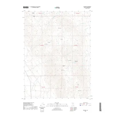
2018 Map of The Banjo
USGS Topo · Published 2018About this map
The Granite Range dominates this corner of Washoe County, characterized by a series of steep drainages and high meadows that illustrate the arid high-elevation geography of northwestern Nevada. The area is defined by its water sources, where Garden Springs, Summit Spring, and the Heward Reservoir provide critical points of relief in a landscape carved by Rock Cr and Clear Cr. A distinct topographic formation known as The Banjo sits at the center of the sheet, while high points like Granite Peak and natural depressions such as Miller Basin show the extreme vertical relief of the region. This 2018 survey details a network of canyons and gulches, including Sheds Gulch and Bowen Canyon, which historically dictated the movement of people and livestock through passages like Wagon Tire Pass.
Find a feature on this map
29 named features on this map. Tap any name to fly to it.
Don’t see what you’re looking for? This feature index may not catch every label — zoom into the map to look around manually.
Map Details
Editions of this 2018 The Banjo Map
This is the sole edition of this map. No revisions or reprints were ever made.
Other maps of this area

1886 · Granite Range
USGS Topo · 1:250,000

1894 · Granite Range
USGS Topo · 1:250,000

1955 · Lovelock
USGS Topo · 1:250,000

1959 · Lovelock
USGS Topo · 1:250,000

1964 · Gerlach
USGS Topo · 1:62,500

1980 · Melody Mountain
USGS Topo · 1:24,000
1980 · The Banjo
USGS Topo · 1:24,000
1980 · Hualapai Flat North
USGS Topo · 1:24,000

1980 · Wall Spring
USGS Topo · 1:24,000
1980 · Hualapai Flat South
USGS Topo · 1:24,000