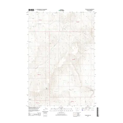
2014 Map of The Big Slide
USGS Topo · Published 2014About this map
The Big Slide dominates this Carbon County landscape, a prominent geological feature set within a network of drainage basins and high bluffs. The terrain is defined by the carved paths of Stanley Cr, Cherry Spring Cr, and Elbow Cr, which flow through various townships. To the south, the Dry Creek Basin and the elevation of Gramps Bluff overlook the confluence of Sand Cr and Fork Sand Cr. This 2014 survey by the U.S. Geological Survey documents a remote section of Montana where the primary human footprint is a sparse grid of access roads. Notable routes such as Cherry Springs Rd and Elbow Creek Rd navigate the steep topography, providing access to landmarks like Cherry Spring and the high plateaus of the Big Slide quadrangle.
Find a feature on this map
25 named features on this map. Tap any name to fly to it.
Don’t see what you’re looking for? This feature index may not catch every label — zoom into the map to look around manually.
Map Details
Editions of this 2014 The Big Slide Map
This is the sole edition of this map. No revisions or reprints were ever made.
Other maps of this area

1932 · Red Lodge No 1
USGS Topo · 1:48,000

1944 · Red Lodge
USGS Topo · 1:62,500

1954 · Billings
USGS Topo · 1:250,000

1956 · Bridger
USGS Topo · 1:24,000

1956 · Fromberg
USGS Topo · 1:24,000

1956 · Roberts
USGS Topo · 1:24,000
1956 · Boyd
USGS Topo · 1:24,000

1956 · The Big Slide
USGS Topo · 1:24,000
1956 · Cooney Reservoir
USGS Topo · 1:24,000

1957 · Billings
USGS Topo · 1:250,000