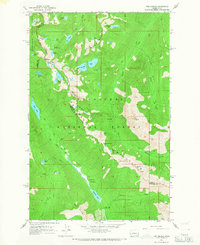
1965 Map of The Cradle
USGS Topo · Published 1967About this map
High-altitude glacial terrain and a network of technical alpine trails characterize this 1965 survey of the Wenatchee Mountains. The map is centered on the prominent peak of The Cradle and serves as a detailed record of the upper Cle Elum River basin before the modern era of heavy recreational development. Notable landmarks such as the Fish Lake Guard Station and several remote campgrounds like Scatter Creek Campground mark the few points of human infrastructure within the intersection of the Snoqualmie National Forest and the Wenatchee National Forest.
Find a feature on this map
47 named features on this map. Tap any name to fly to it.
Don’t see what you’re looking for? This feature index may not catch every label — zoom into the map to look around manually.
Map Details
Editions of this 1965 The Cradle Map
Other maps of this area

1897 · Mount Stuart
USGS Topo · 1:125,000

1901 · Chiwaukum
USGS Topo · 1:125,000

1901 · Snoqualmie Pass
USGS Topo · 1:125,000

1902 · Skykomish
USGS Topo · 1:125,000

1902 · Mount Stuart
USGS Topo · 1:125,000

1903 · Snoqualmie
USGS Topo · 1:125,000

1904 · Chiwaukum
USGS Topo · 1:125,000

1905 · Skykomish
USGS Topo · 1:125,000

1957 · Wenatchee
USGS Topo · 1:250,000

1961 · Mount Stuart
USGS Topo · 1:62,500