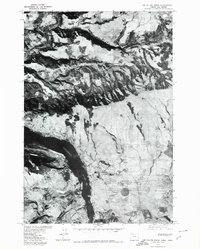
1975 Map of The Dalles North
USGS Topo · Published 1980About this map
The Columbia River carves a deep path through the landscape of the Pacific Northwest in this orthophotograph produced from 1975 aerial imagery. The high-contrast black-and-white photography captures the distinct textural shift between the water, the carved riverbanks, and the agricultural lands bordering the river. The smaller Klickitat River feeds into the main waterway from the north, revealing the sharp relief and drainage patterns characteristic of this region near the Oregon and Washington border.
Find a feature on this map
5 named features on this map. Tap any name to fly to it.
Don’t see what you’re looking for? This feature index may not catch every label — zoom into the map to look around manually.
Map Details
Editions of this 1975 The Dalles North Map
This is the sole edition of this map. No revisions or reprints were ever made.
Other maps of this area

1934 · The Dalles
USGS Topo · 1:125,000

1953 · The Dalles
USGS Topo · 1:250,000

1956 · The Dalles
USGS Topo · 1:250,000

1957 · The Dalles
USGS Topo · 1:250,000

1957 · Klickitat
USGS Topo · 1:62,500

1957 · The Dalles
USGS Topo · 1:62,500

1957 · White Salmon
USGS Topo · 1:62,500

1957 · Husum
USGS Topo · 1:62,500

1974 · Stacker Butte
USGS Topo · 1:24,000

1974 · The Dalles North
USGS Topo · 1:24,000