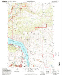
1994 Map of The Dalles North
USGS Topo · Published 1995About this map
The Columbia River forms a massive geographic and political divide here, separating Washington and Oregon through the heart of the Columbia River Gorge National Scenic Area. On the Washington side, the Columbia Hills rise sharply above settlements like Murdock and Smithville, while the Klickitat Wild and Scenic River carves a winding path through Knight Canyon and Dillacort Canyon. The landscape is a study in industrial and transportation history, featuring the Burlington Northern railroad lines following the water's edge and a large Aluminum Plant situated near the riverbanks.
Find a feature on this map
62 named features on this map. Tap any name to fly to it.
Don’t see what you’re looking for? This feature index may not catch every label — zoom into the map to look around manually.
Map Details
Editions of this 1994 The Dalles North Map
This is the sole edition of this map. No revisions or reprints were ever made.
Other maps of this area

1934 · The Dalles
USGS Topo · 1:125,000

1953 · The Dalles
USGS Topo · 1:250,000

1956 · The Dalles
USGS Topo · 1:250,000

1957 · The Dalles
USGS Topo · 1:250,000

1957 · Klickitat
USGS Topo · 1:62,500

1957 · The Dalles
USGS Topo · 1:62,500

1957 · White Salmon
USGS Topo · 1:62,500

1957 · Husum
USGS Topo · 1:62,500

1974 · Stacker Butte
USGS Topo · 1:24,000

1974 · The Dalles North
USGS Topo · 1:24,000