
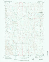
1971 Map of The Gap SW
USGS Topo · Published 1974About this map
Green Oil Field dominates the landscape of this northeastern Wyoming prairie, reflecting the early 1970s energy extraction era. The terrain is defined by a dense network of intermittent drainages like Bone Pile Creek and Duck Nest Creek that feed into the winding Caballo Creek. Human activity is concentrated around industrial and social hubs such as Maysdorf and the G-M Clubhouse, while the inclusion of the Marquis Landing Strips suggests the logistical demands of a remote resource economy. Multiple Oil Well sites and a prominent Pipeline trace the development of the Powder River Basin’s natural resources, set against a backdrop of traditional rangeland accessed by local routes like Bishop Road and T 7 Road.
Find a feature on this map
18 named features on this map. Tap any name to fly to it.
Don’t see what you’re looking for? This feature index may not catch every label — zoom into the map to look around manually.
Map Details
Editions of this 1971 The Gap SW Map
2 editions found
Other maps of this area

1954 · Gillette
USGS Topo · 1:250,000

1955 · Newcastle
USGS Topo · 1:250,000

1955 · Gillette
USGS Topo · 1:250,000

1958 · Gillette
USGS Topo · 1:250,000

1958 · Newcastle
USGS Topo · 1:250,000

1959 · North Star School
USGS Topo · 1:62,500

1962 · Gillette
USGS Topo · 1:250,000

1971 · Scaper Reservoir
USGS Topo · 1:24,000

1971 · Coyote Draw
USGS Topo · 1:24,000
1971 · Saddle Horse Butte
USGS Topo · 1:24,000