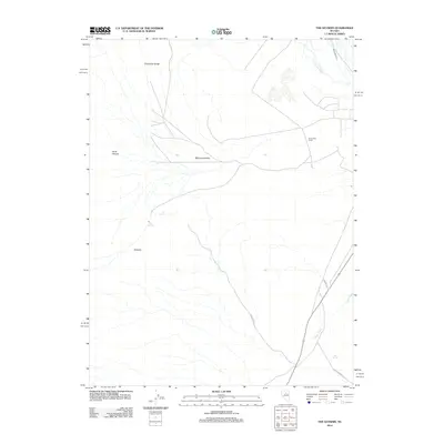
2012 Map of The Geysers
USGS Topo · Published 2012About this map
The Geysers and Hot Springs emerge as central hydrothermal landmarks in this 2012 survey of Lander County. The landscape is defined by the high elevations of the Shoshone Range and the geological formation of the Malpais, which drop away into the wide expanse of Whirlwind Valley. Water management is evident through the presence of the Westside Ditch and the natural drainage of Coyote Creek, which winds through the eastern portion of the quadrangle. Human activity is concentrated around the Sansening Ranch and various specialized transport and utility points, including a designated Transfer Site. The network of local roads such as Panning Rd and Gold Spring Pt provides access to remote reaches like Mule Canyon and the geothermal activity at Cold Springs, illustrating the intersection of ranching and natural resource exploration.
Find a feature on this map
13 named features on this map. Tap any name to fly to it.
Don’t see what you’re looking for? This feature index may not catch every label — zoom into the map to look around manually.
Map Details
Editions of this 2012 The Geysers Map
This is the sole edition of this map. No revisions or reprints were ever made.
Other maps of this area

1949 · Crescent Valley
USGS Topo · 1:62,500

1950 · Crescent Valley
USGS Topo · 1:62,500

1955 · Winnemucca
USGS Topo · 1:250,000

1957 · Frenchie Creek
USGS Topo · 1:62,500

1957 · Dunphy
USGS Topo · 1:62,500

1957 · Beowawe
USGS Topo · 1:62,500

1958 · Winnemucca
USGS Topo · 1:250,000

1962 · Winnemucca
USGS Topo · 1:250,000

1985 · Mud Spring Gulch
USGS Topo · 1:24,000
1985 · Crescent Valley
USGS Topo · 1:24,000