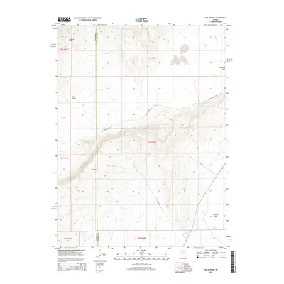
2014 Map of The Geysers
USGS Topo · Published 2014About this map
The Geysers and their associated Hot Springs define this high-desert landscape along the border of Lander and Eureka Counties. The terrain is marked by the steep slopes of the Shoshone Range to the northwest and the volcanic features of Malpais further south. This 2014 survey documents the hydrogeology of the region, showing the contrast between the geothermal activity at The Geysers and the Cold Springs found at the base of Crescent Valley. Transport and access are limited to industrial and rural routes like Beowawe Geyser Rd and Transfer Site Rd, which navigate the elevation changes between the Whirlwind Valley and the surrounding peaks. Water management is evident through features like the Westside Ditch and Coyote Cr, reflecting the vital importance of water resources in this arid Nevada environment.
Find a feature on this map
20 named features on this map. Tap any name to fly to it.
Don’t see what you’re looking for? This feature index may not catch every label — zoom into the map to look around manually.
Map Details
Editions of this 2014 The Geysers Map
This is the sole edition of this map. No revisions or reprints were ever made.
Other maps of this area

1949 · Crescent Valley
USGS Topo · 1:62,500

1950 · Crescent Valley
USGS Topo · 1:62,500

1955 · Winnemucca
USGS Topo · 1:250,000

1957 · Frenchie Creek
USGS Topo · 1:62,500

1957 · Dunphy
USGS Topo · 1:62,500

1957 · Beowawe
USGS Topo · 1:62,500

1958 · Winnemucca
USGS Topo · 1:250,000

1962 · Winnemucca
USGS Topo · 1:250,000

1985 · Mud Spring Gulch
USGS Topo · 1:24,000
1985 · Crescent Valley
USGS Topo · 1:24,000