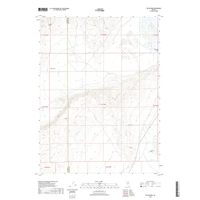
2018 Map of The Geysers
USGS Topo · Published 2018About this map
The Geysers and Hot Springs mark a distinctive geothermal landscape along the border of Lander and Eureka counties. The terrain is defined by the steep elevations of the Shoshone Range to the northwest and the volcanic features of the Malpais. This high-desert environment shows a clear transition from the rugged drainage of Mule Canyon down into the broader flats of Whirlwind Valley and Crescent Valley, where water management is evident through features like the Westside Ditch.
Find a feature on this map
21 named features on this map. Tap any name to fly to it.
Don’t see what you’re looking for? This feature index may not catch every label — zoom into the map to look around manually.
Map Details
Editions of this 2018 The Geysers Map
This is the sole edition of this map. No revisions or reprints were ever made.
Other maps of this area

1949 · Crescent Valley
USGS Topo · 1:62,500

1950 · Crescent Valley
USGS Topo · 1:62,500

1955 · Winnemucca
USGS Topo · 1:250,000

1957 · Frenchie Creek
USGS Topo · 1:62,500

1957 · Dunphy
USGS Topo · 1:62,500

1957 · Beowawe
USGS Topo · 1:62,500

1958 · Winnemucca
USGS Topo · 1:250,000

1962 · Winnemucca
USGS Topo · 1:250,000

1985 · Mud Spring Gulch
USGS Topo · 1:24,000
1985 · Crescent Valley
USGS Topo · 1:24,000