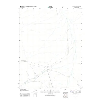
2012 Map of The Monitor
USGS Topo · Published 2012About this map
Monitor Ranch and The Homestead sit at the intersection of a sparse road network in this high-elevation Nevada landscape. The terrain is defined by the eastern slopes of the Toiyabe Range, where drainage patterns like Stoneberger Cr and Willow Cr carve through the arid basin. Named features like The Monitor and Sams Canyon provide orientation points in a region dominated by vast open range and National Forest land. The presence of Laxague and several designated Forest Service routes, such as NFD 001 RD, indicates the area's continued use for ranching and resource management. This map illustrates the intersection of historical grazing lands and the rugged topography of the Great Basin.
Find a feature on this map
13 named features on this map. Tap any name to fly to it.
Don’t see what you’re looking for? This feature index may not catch every label — zoom into the map to look around manually.
Map Details
Editions of this 2012 The Monitor Map
This is the sole edition of this map. No revisions or reprints were ever made.
Other maps of this area

1926 · Roberts Mountains
USGS Topo · 1:250,000

1929 · Roberts Mountains
USGS Topo · 1:250,000

1955 · Millett
USGS Topo · 1:250,000

1959 · Millett
USGS Topo · 1:250,000

1960 · Hickison Summit
USGS Topo · 1:62,500

1960 · Spencer Hot Springs
USGS Topo · 1:62,500

1960 · Dianas Punch Bowl
USGS Topo · 1:62,500

1960 · Wildcat Peak
USGS Topo · 1:62,500

1978 · Summit Mountain
USGS Topo · 1:100,000
1989 · Dianas Punch Bowl
USGS Topo · 1:24,000