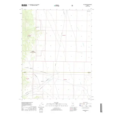
2018 Map of The Monitor
USGS Topo · Published 2018About this map
The Monitor sits at a geographic crossroads in central Nevada, where the high ridges of the Toquima Range descend into the broad Monitor Valley. This 2018 survey reveals a landscape of high-desert drainage patterns and managed public lands, dominated by the eastern portions of the Toiyabe National Forest. Water is a defining scarce resource here, marked by E Toquima Spring and the seasonal flows of Stoneberger Cr and Willow Cr as they move toward the Stoneberger Basin. The map documents a network of remote access routes, including Belmont Rd and Petes Summit Road, that reflect the region's ranching and resource management history. The boundary line between Lander Co and Nye Co cuts through the center of the sheet, providing a precise reference for those researching land ownership or jurisdictional history in these remote Great Basin basins.
Find a feature on this map
21 named features on this map. Tap any name to fly to it.
Don’t see what you’re looking for? This feature index may not catch every label — zoom into the map to look around manually.
Map Details
Editions of this 2018 The Monitor Map
This is the sole edition of this map. No revisions or reprints were ever made.
Other maps of this area

1926 · Roberts Mountains
USGS Topo · 1:250,000

1929 · Roberts Mountains
USGS Topo · 1:250,000

1955 · Millett
USGS Topo · 1:250,000

1959 · Millett
USGS Topo · 1:250,000

1960 · Hickison Summit
USGS Topo · 1:62,500

1960 · Spencer Hot Springs
USGS Topo · 1:62,500

1960 · Dianas Punch Bowl
USGS Topo · 1:62,500

1960 · Wildcat Peak
USGS Topo · 1:62,500

1978 · Summit Mountain
USGS Topo · 1:100,000
1989 · Dianas Punch Bowl
USGS Topo · 1:24,000