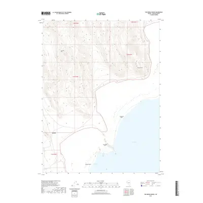
2018 Map of The Needle Rocks
USGS Topo · Published 2018About this map
The northwest shoreline of Pyramid Lake defines this Washoe County landscape, where geothermal activity and striking geological formations meet the water. At the heart of the coast, The Needle Rocks stand near a Steam Geyser and Hot Spring, marking a site of significant thermal energy. To the west, the Terraced Hills rise sharply from the basin, their dramatic topography contrasting with the level reaches of Enchanted Beach and Wizards Beach. In the southern portion of the quadrangle, the small settlement of Zenobia is situated near the foot of the hills, providing a human anchor to this largely undeveloped shoreline. The map captures the specialized environment of Wizards Cove and the prominent Terrace Point, illustrating the complex interplay between Nevada's high-desert terrain and its terminal lake systems.
Find a feature on this map
15 named features on this map. Tap any name to fly to it.
Don’t see what you’re looking for? This feature index may not catch every label — zoom into the map to look around manually.
Map Details
Editions of this 2018 The Needle Rocks Map
This is the sole edition of this map. No revisions or reprints were ever made.
Other maps of this area

1886 · Granite Range
USGS Topo · 1:250,000

1894 · Granite Range
USGS Topo · 1:250,000

1955 · Lovelock
USGS Topo · 1:250,000

1959 · Lovelock
USGS Topo · 1:250,000

1964 · The Needle Rocks
USGS Topo · 1:24,000
1964 · Pyramid SW
USGS Topo · 1:24,000
1964 · Astor Pass
USGS Topo · 1:24,000

1964 · Pyramid NE
USGS Topo · 1:24,000
1964 · Spanish Flat
USGS Topo · 1:24,000

1965 · Fox Range
USGS Topo · 1:62,500