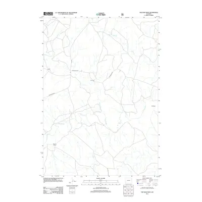
2012 Map of The Nose West
USGS Topo · Published 2012About this map
Cheyenne River winds through the central portion of this eastern Wyoming landscape, joined by its northern tributaries in a region defined by ranching and drainage networks. The map documents the spatial relationship between isolated properties like Bruce Ranch and Fisher Ranch, which serve as the primary landmarks in this sparsely populated terrain. Transportation in the area relies on a handful of through-routes, most notably Cheyenne River Rd and Bruce Rd, connecting the scattered homesteads to the wider county. The topography is marked by distinctive natural features such as The Nose and Barrel Draw, while significant waterways like Black Thunder Cr and Wildcat Cr provide the essential framework for understanding the local hydrography and historical land use patterns in this high plains environment.
Find a feature on this map
9 named features on this map. Tap any name to fly to it.
Don’t see what you’re looking for? This feature index may not catch every label — zoom into the map to look around manually.
Map Details
Editions of this 2012 The Nose West Map
This is the sole edition of this map. No revisions or reprints were ever made.
Other maps of this area

1955 · Newcastle
USGS Topo · 1:250,000

1958 · Newcastle
USGS Topo · 1:250,000

1979 · Newcastle
USGS Topo · 1:100,000

1981 · Horseshoe Bend
USGS Topo · 1:24,000

1981 · Garland Draw
USGS Topo · 1:24,000

1981 · Wagonhound Creek NE
USGS Topo · 1:24,000

1981 · Lance Creek
USGS Topo · 1:100,000
1982 · Poddy Creek
USGS Topo · 1:24,000

1982 · Clareton
USGS Topo · 1:24,000
1982 · The Nose East
USGS Topo · 1:24,000