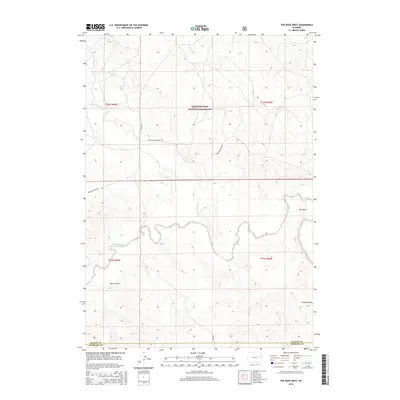
2015 Map of The Nose West
USGS Topo · Published 2015About this map
Thunder Basin National Grassland dominates this high plains landscape in eastern Wyoming, where the drainage systems of the Cheyenne River and Black Thunder Cr define the rolling topography. The area is characterized by a sparse network of ranch roads including Cheyenne River Rd and Bruce Rd, reflecting the remote nature of this grazing country. A prominent geological formation known as The Nose marks the eastern portion of the map, situated above the winding path of the river.
Find a feature on this map
15 named features on this map. Tap any name to fly to it.
Don’t see what you’re looking for? This feature index may not catch every label — zoom into the map to look around manually.
Map Details
Editions of this 2015 The Nose West Map
This is the sole edition of this map. No revisions or reprints were ever made.
Other maps of this area

1955 · Newcastle
USGS Topo · 1:250,000

1958 · Newcastle
USGS Topo · 1:250,000

1979 · Newcastle
USGS Topo · 1:100,000

1981 · Horseshoe Bend
USGS Topo · 1:24,000

1981 · Garland Draw
USGS Topo · 1:24,000

1981 · Wagonhound Creek NE
USGS Topo · 1:24,000

1981 · Lance Creek
USGS Topo · 1:100,000
1982 · Poddy Creek
USGS Topo · 1:24,000

1982 · Clareton
USGS Topo · 1:24,000
1982 · The Nose East
USGS Topo · 1:24,000