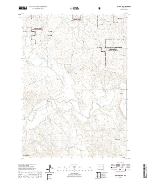
2021 Map of The Nose West
USGS Topo · Published 2021About this map
Thunder Basin National Grassland dominates this section of the High Plains, where the terrain is defined by the deep incisions of the Cheyenne River and its various tributaries. This 2021 survey shows a landscape largely shaped by grazing and drainage, with prominent landmarks such as the elevated feature known as The Nose rising above the surrounding draws. The hydrology is particularly detailed, tracing the winding paths of Black Thunder Cr, Wildcat Cr, and the seasonal paths of Graham Draw and Barrel Draw.
Find a feature on this map
14 named features on this map. Tap any name to fly to it.
Don’t see what you’re looking for? This feature index may not catch every label — zoom into the map to look around manually.
Map Details
Editions of this 2021 The Nose West Map
This is the sole edition of this map. No revisions or reprints were ever made.
Other maps of this area

1955 · Newcastle
USGS Topo · 1:250,000

1958 · Newcastle
USGS Topo · 1:250,000

1979 · Newcastle
USGS Topo · 1:100,000

1981 · Horseshoe Bend
USGS Topo · 1:24,000

1981 · Garland Draw
USGS Topo · 1:24,000

1981 · Wagonhound Creek NE
USGS Topo · 1:24,000

1981 · Lance Creek
USGS Topo · 1:100,000
1982 · Poddy Creek
USGS Topo · 1:24,000

1982 · Clareton
USGS Topo · 1:24,000
1982 · The Nose East
USGS Topo · 1:24,000