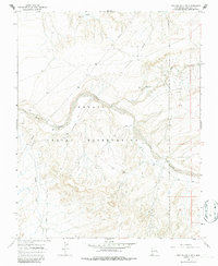
1966 Map of The Pillar 3 NE
USGS Topo · Published 1987About this map
The Navajo Indian Reservation dominates this high-desert landscape in northwestern New Mexico, where the intricate hydrology of the San Juan Basin is on full display. The Chaco River snakes through the central terrain, joined by seasonal watercourses including De-na-zin Wash, Hunter Wash, and Indian Creek. This 1966 field survey reveals a land defined by its natural drainages and the emerging industrial infrastructure of the mid-century, specifically a long-distance Pipeline cutting across the northwestern and central sectors. While the territory appears largely unpopulated, the presence of scattered wells and a specific Mine site indicates active resource extraction and water management during this era. The topographic detail highlights the complex erosion patterns and mesa edges characteristic of this region, providing a clear record of the land before modern developments.
Find a feature on this map
8 named features on this map. Tap any name to fly to it.
Don’t see what you’re looking for? This feature index may not catch every label — zoom into the map to look around manually.
Map Details
Editions of this 1966 The Pillar 3 NE Map
4 editions found
Other maps of this area

1889 · Chaco
USGS Topo · 1:250,000

1892 · Chaco
USGS Topo · 1:250,000

1927 · Sulphur Spring
USGS Topo · 1:96,000

1928 · Kirtland
USGS Topo · 1:125,000

1932 · Kirtland
USGS Topo · 1:125,000

1954 · Shiprock
USGS Topo · 1:250,000

1958 · Shiprock
USGS Topo · 1:250,000

1959 · Shiprock
USGS Topo · 1:250,000
1966 · Tanner Lake
USGS Topo · 1:24,000
1966 · Alamo Mesa West
USGS Topo · 1:24,000