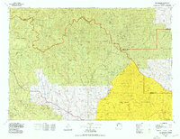
1978 Map of The Ramshorn
USGS Topo · Published 1979About this map
Absaroka Range peaks and high mountain passes dominate this late-1970s survey of the Wyoming high country. The town of Dubois sits along the Wind River, serving as a gateway to the surrounding wilderness areas, including the Washakie Wilderness and Teton Wilderness. The map illustrates a complex network of hydrological origins, with the headwaters of the Yellowstone River, Shoshone River, and Greybull River all radiating from these central highlands. The Continental Divide carves a jagged path through the western portion of the sheet, separating the drainages of the South Fork Buffalo Fork from the high plateaus. Land management patterns are clearly defined, showing the interface between the Wind River Indian Reservation and several national forests. Notable high-altitude features include Ramshorn Peak, Younts Peak, and the site of Kirwin, illustrating the remote nature of early alpine settlement and mapping.
Find a feature on this map
136 named features on this map. Tap any name to fly to it.
Don’t see what you’re looking for? This feature index may not catch every label — zoom into the map to look around manually.
Map Details
Editions of this 1978 The Ramshorn Map
2 editions found
Other maps of this area

1885 · Lake
USGS Topo · 1:125,000

1893 · Ishawooa
USGS Topo · 1:125,000

1895 · Ishawooa
USGS Topo · 1:125,000

1895 · Lake
USGS Topo · 1:125,000

1896 · Lake
USGS Topo · 1:125,000

1899 · Ishawooa
USGS Topo · 1:125,000

1901 · Lake
USGS Topo · 1:125,000

1902 · Mt Leidy
USGS Topo · 1:125,000

1904 · Kirwin
USGS Topo · 1:125,000

1905 · Younts Peak
USGS Topo · 1:125,000