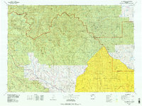
1978 Map of The Ramshorn
USGS Topo · Published 1979About this map
Dubois stands as the primary gateway to this high-altitude landscape in the late 1970s, positioned along the Wind River where Us 287 and Us 26 provide access to the surrounding wilderness. The map documents a convergence of massive protected lands, including the Teton National Forest and Shoshone National Forest, divided by the high spine of the Continental Divide. The drainage patterns are significant, showing the headwaters of the Yellowstone River and Thorofare River flowing north, while the Greybull River and Wood River reach toward the eastern plains. A notable pocket of human history is visible at Kirwin, located at the base of Spar Mountain, while the southeastern corner is dominated by the geometric boundaries and high plateaus of the Wind River Indian Reservation. Landmark features like The Ramshorn and Washakie Needles serve as critical navigational points across the Absaroka Range.
Find a feature on this map
58 named features on this map. Tap any name to fly to it.
Don’t see what you’re looking for? This feature index may not catch every label — zoom into the map to look around manually.
Map Details
Editions of this 1978 The Ramshorn Map
2 editions found
Other maps of this area

1885 · Lake
USGS Topo · 1:125,000

1893 · Ishawooa
USGS Topo · 1:125,000

1895 · Ishawooa
USGS Topo · 1:125,000

1895 · Lake
USGS Topo · 1:125,000

1896 · Lake
USGS Topo · 1:125,000

1899 · Ishawooa
USGS Topo · 1:125,000

1901 · Lake
USGS Topo · 1:125,000

1902 · Mt Leidy
USGS Topo · 1:125,000

1904 · Kirwin
USGS Topo · 1:125,000

1905 · Younts Peak
USGS Topo · 1:125,000