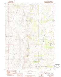
1985 Map of The Rock Slide
USGS Topo · Published 1985About this map
Tunp Range and Rock Creek Ridge dominate this high-altitude landscape in Lincoln County, characterized by a series of north-south running ridges and deep canyons. The southern portion of the sheet is marked by the northern boundary of Fossil Butte National Monument, including drainage features like Millet Canyon. This mid-1980s provisional survey shows a terrain defined by its water sources and geological shifts, notably the namesake The Rock Slide located along the western slopes of the Tunp Range.
Find a feature on this map
25 named features on this map. Tap any name to fly to it.
Don’t see what you’re looking for? This feature index may not catch every label — zoom into the map to look around manually.
Map Details
Editions of this 1985 The Rock Slide Map
This is the sole edition of this map. No revisions or reprints were ever made.
Other maps of this area

1936 · Cokeville
USGS Topo · 1:96,000

1942 · Cokeville
USGS Topo · 1:125,000

1954 · Sage
USGS Topo · 1:62,500

1954 · Ogden
USGS Topo · 1:250,000

1954 · Kemmerer
USGS Topo · 1:62,500

1955 · Preston
USGS Topo · 1:250,000

1958 · Ogden
USGS Topo · 1:250,000

1958 · Preston
USGS Topo · 1:250,000

1960 · Ogden
USGS Topo · 1:250,000

1962 · Preston
USGS Topo · 1:250,000