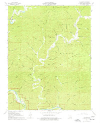
1968 Map of The Sinks
USGS Topo · Published 1977About this map
The Sinks and the complex drainage of the Ozark plateau define this landscape, where Sinking Creek disappears into a Cave at the foot of a bluff. The map illustrates a rural environment shaped by steep hollows and family-named landmarks during the late 1960s. Settlers and their descendants left their marks at Heaton Cem and Mauser Mill, while the southern portion of the sheet is dominated by the protected corridors of the Ozark National Scenic Riverways. Terrain features such as Boardinghouse Hol, Smokehouse Hol, and Mail Route Hollow provide insights into the early pioneer lifestyle and transport routes of Shannon County. Most of the northern territory is situated within the Clark National Forest, maintaining the heavily timbered character of the Current River watershed before modern development expanded.
Find a feature on this map
68 named features on this map. Tap any name to fly to it.
Don’t see what you’re looking for? This feature index may not catch every label — zoom into the map to look around manually.
Map Details
Editions of this 1968 The Sinks Map
4 editions found
Other maps of this area

1915 · Eminence
USGS Topo · 1:62,500

1917 · Eminence
USGS Topo · 1:62,500

1928 · Cardareva
USGS Topo · 1:62,500

1944 · Corridon
USGS Topo · 1:62,500

1945 · Round Spring
USGS Topo · 1:62,500

1947 · Sinkin
USGS Topo · 1:48,000

1947 · Corridon
USGS Topo · 1:62,500

1949 · Round Spring
USGS Topo · 1:62,500

1949 · Rolla
USGS Topo · 1:250,000

1949 · Cardareva
USGS Topo · 1:62,500