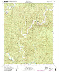
1968 Map of The Sinks
USGS Topo · Published 1985About this map
The Sinks serves as a prominent natural landmark where Sinking Creek enters a limestone subterranean passage, a defining geological feature of this Shannon County landscape. The area is heavily marked by intricate drainages and family-named landmarks like Mauser Mill and the Heaton Cem, reflecting the early rural settlement patterns within the Mark Twain National Forest. The 1968 field survey, updated in the mid-1980s, captures a snapshot of the terrain before extensive modern development, highlighting steep ridges like Upper Dugan Bluff and Lower Dugan Bluff that overlook the winding path of Big Creek. Along the southern edge, the Current River flows through the Ozark National Scenic Riverways, flanked by landmarks such as Bee Bluff. This map is particularly valuable for its recording of numerous local hollow names, including Graveyard Hollow and Mail Route Hollow, which preserve the history of regional navigation and family homesteads.
Find a feature on this map
66 named features on this map. Tap any name to fly to it.
Don’t see what you’re looking for? This feature index may not catch every label — zoom into the map to look around manually.
Map Details
Editions of this 1968 The Sinks Map
4 editions found
Other maps of this area

1915 · Eminence
USGS Topo · 1:62,500

1917 · Eminence
USGS Topo · 1:62,500

1928 · Cardareva
USGS Topo · 1:62,500

1944 · Corridon
USGS Topo · 1:62,500

1945 · Round Spring
USGS Topo · 1:62,500

1947 · Sinkin
USGS Topo · 1:48,000

1947 · Corridon
USGS Topo · 1:62,500

1949 · Round Spring
USGS Topo · 1:62,500

1949 · Rolla
USGS Topo · 1:250,000

1949 · Cardareva
USGS Topo · 1:62,500