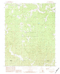
1983 Map of Low Wassie
USGS Topo · Published 1984About this map
The town of Winona and the surrounding timberlands of the Mark Twain National Forest define this early 1980s landscape on the border of Shannon and Oregon counties. The area’s industrial history is etched into the terrain through transportation remnants like the Old Pike Railroad Grade and the Old Tram Road, which once served the local logging and mining interests. Small clusters of settlement at Low Wassie and Seaman are connected by a network of improved and unimproved roads winding through the Ozark topography.
Find a feature on this map
41 named features on this map. Tap any name to fly to it.
Don’t see what you’re looking for? This feature index may not catch every label — zoom into the map to look around manually.
Map Details
Editions of this 1983 Low Wassie Map
This is the sole edition of this map. No revisions or reprints were ever made.
Other maps of this area

1915 · Eminence
USGS Topo · 1:62,500

1917 · Eminence
USGS Topo · 1:62,500

1928 · Cardareva
USGS Topo · 1:62,500

1931 · Bandyville
USGS Topo · 1:48,000

1944 · Van Buren
USGS Topo · 1:62,500

1944 · Birch Tree
USGS Topo · 1:62,500

1946 · Van Buren
USGS Topo · 1:62,500

1948 · Birch Tree
USGS Topo · 1:62,500

1949 · Rolla
USGS Topo · 1:250,000

1949 · Cardareva
USGS Topo · 1:62,500