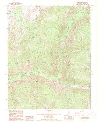
1988 Map of The Sphinx
USGS Topo · Published 1991About this map
Kings Canyon National Park dominates this late-twentieth-century survey, showcasing the dramatic verticality of the Sierra Nevada. The drainage of the South Fork Kings River serves as the central artery, fed by numerous tributaries including Bubbs Creek and Paradise Valley. The map identifies the Kanawyers (Site), a former settlement and stopping point near the canyon floor, providing a specific reference for those tracing early routes through the high country. High-altitude features like the Monarch Divide and the Granite Basin are mapped alongside iconic peaks such as Grand Sentinel and the distinctive formation known as The Sphinx. The presence of several footbridges and established trails through Zumwalt Meadows underscores the area's development for backcountry access during this era, while landmarks like Mist Falls highlight the rugged hydrosystems of the canyon.
Find a feature on this map
34 named features on this map. Tap any name to fly to it.
Don’t see what you’re looking for? This feature index may not catch every label — zoom into the map to look around manually.
Map Details
Editions of this 1988 The Sphinx Map
2 editions found
Other maps of this area

1903 · Tehipite
USGS Topo · 1:125,000

1905 · Tehipite
USGS Topo · 1:125,000

1907 · Mt. Whitney
USGS Topo · 1:125,000

1919 · Mt. Whitney
USGS Topo · 1:125,000

1937 · Mt. Whitney
USGS Topo · 1:125,000

1948 · Fresno
USGS Topo · 1:250,000

1953 · Mt. Pinchot
USGS Topo · 1:62,500

1953 · Marion Peak
USGS Topo · 1:62,500

1955 · Fresno
USGS Topo · 1:250,000

1956 · Fresno
USGS Topo · 1:250,000