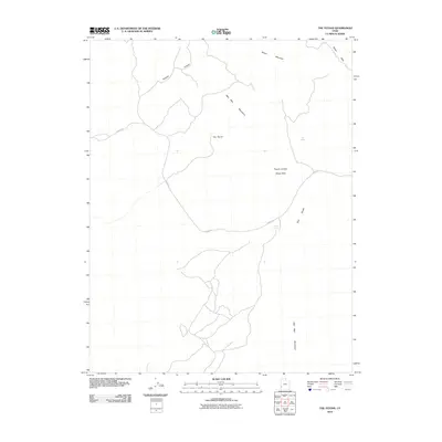
2010 Map of The Tetons
USGS Topo · Published 2010About this map
Wah Wah Mountains topography defines this high-desert landscape in southwestern Utah. The map focuses on the distinctive formations of The Tetons and the adjacent Pink Knolls, revealing a terrain shaped by drainage networks like Sawmill Canyon and Blawn Wash. Human activity in this arid region is largely defined by the presence of water and land management, centered on the Jockey Rd corridor which connects vital water sources such as Jockey Spring and The Seeps. A significant portion of the land is designated as the Pinyon Juniper Study Area, indicating the region's importance for ecological research and rangeland monitoring. The network of primitive roads and 4WD tracks shown here underscores the area's character as a working landscape for grazing or conservation, with elevations rising toward Blawn Mountain in the north.
Find a feature on this map
10 named features on this map. Tap any name to fly to it.
Don’t see what you’re looking for? This feature index may not catch every label — zoom into the map to look around manually.
Map Details
Editions of this 2010 The Tetons Map
This is the sole edition of this map. No revisions or reprints were ever made.
Other maps of this area

1953 · Richfield
USGS Topo · 1:250,000

1958 · Richfield
USGS Topo · 1:250,000

1959 · Frisco
USGS Topo · 1:62,500

1971 · Observation Knoll
USGS Topo · 1:24,000

1971 · Pine Grove Reservoir
USGS Topo · 1:24,000
1971 · Lund
USGS Topo · 1:24,000

1971 · Bible Spring
USGS Topo · 1:24,000
1971 · Blue Mountain
USGS Topo · 1:24,000
1971 · The Tetons
USGS Topo · 1:24,000

1971 · Lamerdorf Peak
USGS Topo · 1:24,000