
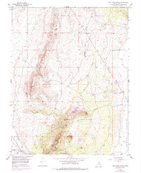
1950 Map of The Three Peaks
USGS Topo · Published 1964About this map
The Three Peaks anchor the southern portion of this landscape, rising prominently above the eastern edge of the Cedar Valley. This mid-century survey documents a region defined by its geology and early mineral exploration, evidenced by scattered prospects and a specific prospect site near the peaks. The industrial character of the area is further emphasized by the presence of the Union Pacific railroad corridor and Antelope Rd, which flank the perennial water sources of Iron Springs Creek and the notable Iron Springs area. To the north, the terrain transitions into the high ground of The Bald Hills and the narrow passage of Horse Hollow. A distinctive geological feature known as Hole in the Wall is also marked along the western ridgeline, offering a specific point of interest for those studying the physical history and early land navigation of Iron County.
Find a feature on this map
12 named features on this map. Tap any name to fly to it.
Don’t see what you’re looking for? This feature index may not catch every label — zoom into the map to look around manually.
Map Details
Editions of this 1950 The Three Peaks Map
2 editions found
Other maps of this area

1885 · St. George
USGS Topo · 1:250,000

1891 · St. George
USGS Topo · 1:250,000

1949 · Cedar City NW
USGS Topo · 1:24,000

1950 · Cedar City NW
USGS Topo · 1:24,000

1950 · Enoch
USGS Topo · 1:24,000

1950 · Cedar City
USGS Topo · 1:24,000

1950 · Enoch
USGS Topo · 1:62,500

1950 · Iron Mountain
USGS Topo · 1:62,500

1950 · Cedar City
USGS Topo · 1:62,500

1950 · Enoch NE
USGS Topo · 1:24,000