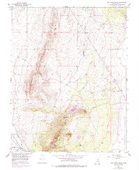
1950 Map of The Three Peaks
USGS Topo · Published 1979About this map
Iron Springs serves as a focal point for this survey of the western Cedar Valley, where the Union Pacific railroad tracks cut across the arid landscape near Iron Springs Creek. The terrain is defined by the sharp elevations of The Three Peaks and the northern reach of The Bald Hills. Industrial activity is evident in several Prospects and a standalone Prospect located near the peaks, suggesting the area's significance for mineral exploration during the mid-20th century.
Find a feature on this map
15 named features on this map. Tap any name to fly to it.
Don’t see what you’re looking for? This feature index may not catch every label — zoom into the map to look around manually.
Map Details
Editions of this 1950 The Three Peaks Map
2 editions found
Other maps of this area

1885 · St. George
USGS Topo · 1:250,000

1891 · St. George
USGS Topo · 1:250,000

1949 · Cedar City NW
USGS Topo · 1:24,000

1950 · Cedar City NW
USGS Topo · 1:24,000

1950 · Enoch
USGS Topo · 1:24,000

1950 · Cedar City
USGS Topo · 1:24,000

1950 · Enoch
USGS Topo · 1:62,500

1950 · Iron Mountain
USGS Topo · 1:62,500

1950 · Cedar City
USGS Topo · 1:62,500

1950 · The Three Peaks
USGS Topo · 1:24,000