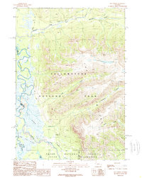
1989 Map of The Trident
USGS Topo · Published 1989About this map
Yellowstone National Park and the adjacent Teton Wilderness meet in this remote high-altitude landscape, where the Yellowstone River snakes through a broad valley floor before entering the southern reaches of the park. This territory is defined by its lack of roads, relying instead on a network of routes like the Thorofare (Pack) Trail and various other Pack Trails to navigate the steep topography. The most significant human outpost is the Thorofare Ranger Station, situated near the confluence of the river and Thorofare Creek. This station represents one of the most distant backcountry locations in the lower forty-eight states. Massive geological formations dominate the eastern skyline, specifically the massive The Trident and its accompanying Escarpment. To the south, Bridger Lake sits at the edge of the Teton National Forest, serving as a landmark for travelers moving between the drainage of Mountain Creek and the southern river forks.
Find a feature on this map
21 named features on this map. Tap any name to fly to it.
Don’t see what you’re looking for? This feature index may not catch every label — zoom into the map to look around manually.
Map Details
Editions of this 1989 The Trident Map
This is the sole edition of this map. No revisions or reprints were ever made.
Other maps of this area

1885 · Lake
USGS Topo · 1:125,000

1893 · Ishawooa
USGS Topo · 1:125,000

1895 · Ishawooa
USGS Topo · 1:125,000

1895 · Lake
USGS Topo · 1:125,000

1896 · Lake
USGS Topo · 1:125,000

1899 · Ishawooa
USGS Topo · 1:125,000

1901 · Lake
USGS Topo · 1:125,000

1906 · Lake
USGS Topo · 1:125,000

1911 · Lake
USGS Topo · 1:125,000

1955 · Ashton
USGS Topo · 1:250,000